| Lingua: |


|
Nazione: |


Willersdorfer Schlucht
Die Willersdorfer Schlucht ist eine Aulandschaft im Dreiländereck
di eisenstaedter
 Austria > Burgenland > Südburgenland
|
|
||||
|
|||||


 Dimensioni: piccola
 Stato: disponibile
 Nascosta il: 23. agosto 2006
 Pubblicata anche su:
  5 trovata
 0 non trovata
 3 Note
 0 Osservata
 0 Ignorata
 262 Pagina visite
 2
2 

![]() Descrizione
Deutsch
(Tedesco)
Descrizione
Deutsch
(Tedesco)
 Die Schlucht beginnt bei Gschaidt (NÖ) und reicht im Süden bis
Willersdorf im Burgenland. Die Willersdorfer Schlucht wird auf
ihrer ganzen Länge vom Willersbach durchflossen.
Die Schlucht beginnt bei Gschaidt (NÖ) und reicht im Süden bis
Willersdorf im Burgenland. Die Willersdorfer Schlucht wird auf
ihrer ganzen Länge vom Willersbach durchflossen.In der Talsohle (ca 30-50 m breit) wechseln sich Trockenrasen und eiszeitliche Relikte in Form von Auenstreifen ab. Seehöhe: ca 400-620 m über NN Größe: ca 1.220 ha.
Da die Willersdorfer Schlucht ein Ausläufer des den Zentralalpen angehörenden Wechselmassives ist, weist sie viele montane Elemente der Pflanzen- und Tierwelt auf. Die Hänge sind auf Grund ihres Mischwaldbestandes besonders im Herbst von hervorragender landschaftlicher Schönheit.
Der hohe Erholungswert der Landschaft ist in erster Linie auf die Unberührtheit zurückzuführen, was wiederum die Voraussetzung für die erstaunliche Artenvielfalt der Fauna und Flora darstellt.
Wir erleben hier Natur pur.
Der Cache kann auf dem meist flachen Wanderweg (blaue Markierung) leicht von Willersdorf zu Fuß erreicht werden. Eignet sich auch sehr gut für eine Wanderung zu meinem Cache ""Dreiländereck" - OC2400.
Parke Dein cachemobile am Besten am Parkplatz in Willersdorf .
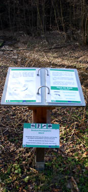
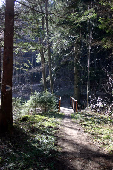
Ein Teil des Weges durch die "Willersdorfer Schlucht" zum Dreiländereck ist als Naturlehrpfad ausgebaut (siehe Photo rechts).
An dieser Stelle noch einmal ein Dankeschön an "BalkanSabranje" für die Idee dieses wunderschönen Caches.
Der Cache ist außerdem sehr gut mit meinen Caches "Tauchen" - OC500A und "Felsenblick" - OC5009 kombinierbar.

![]() Suggerimenti addizionali
Suggerimenti addizionali
![]() Decripta
Decripta
Fhpur qra Fpungm va rvarz ubuyra Onhzfgnzz anur qrz tebßra Fgrva
A|B|C|D|E|F|G|H|I|J|K|L|M
N|O|P|Q|R|S|T|U|V|W|X|Y|Z
![]() Utilità
Utilità
 Cerca geocache vicine:
tutte -
ricercabile -
stesso tipo
Cerca geocache vicine:
tutte -
ricercabile -
stesso tipo
 Scarica come file:
GPX -
LOC -
KML -
OV2 -
OVL -
TXT -
QR-Code
Scarica come file:
GPX -
LOC -
KML -
OV2 -
OVL -
TXT -
QR-Code
 Scaricando questo file accetti i nostri termini di utilizzo e la Licenza dati.
![]() Log per Willersdorfer Schlucht
Log per Willersdorfer Schlucht
![]() 5x
5x
![]() 0x
0x
![]() 3x
3x
 27. luglio 2012
eisenstaedter
ha scritto una nota
27. luglio 2012
eisenstaedter
ha scritto una nota
Koords wurden aktualisiert!
![]() New coordinates:
N 47° 23.310' E 016° 11.208',
moved by 84 meters
New coordinates:
N 47° 23.310' E 016° 11.208',
moved by 84 meters
 18. settembre 2011
alfredz
ha trovato la geocache
18. settembre 2011
alfredz
ha trovato la geocache
Auf einer Wanderung an einem schönen Herbsttag gefunden
DFDC
![]() New coordinates:
N 47° 23.269' E 016° 11.179',
moved by 103 meters
New coordinates:
N 47° 23.269' E 016° 11.179',
moved by 103 meters
29. gennaio 2008
GeoFaex
ha scritto una nota
Cache an eisenstädter übertragen.…
Gruß,
GeoFaex
Team Opencaching.de
25. ottobre 2007
GeoFaex
ha scritto una nota
Cache von "BalkanSabranje" an "ime" übertragen.
Gruß,
GeoFaex
30. marzo 2007
sterau
ha trovato la geocache
Schönes Tal, Schlucht finde ich etwas übertrieben. Leider wird es durch Wildwasserschutzprojekte arg in Mitleidenschaft gezogen. IN: Donau-Murmel OUT: Engerl
TFTC, Sterau & Lisi
20. gennaio 2007
Da.Verna&Di.Andre
ha trovato la geocache
11:20
Die Terrainwertung 4 (wegen der Länge) ist richtig, man braucht doch nur die Beschreibung lesen (Dreiländereck)!
Angenehme Wanderung in der Schlucht, den Bach entlang wieder zum Auto zurück... Der Lehrpfad ist interessant, besonders die Tümpelfauna...
IN: (Schluchten)bär
OUT: EMC²
TFTC!
14. gennaio 2007
Döschwo
ha trovato la geocache
Nette Wanderung durch die schöne "Schlucht" mit sehr informativen Tafeln am Wegrand. Dank Spoilerbild rasch gefunden.
TFTC, Döschwo mit Begleitung
![]() Coordinate:
N 47° 23.217' E 016° 11.209'
Coordinate:
N 47° 23.217' E 016° 11.209'
26. agosto 2006
Gavriel
ha trovato la geocache
Expert timing (= getting up early) helped us to return to the car the very moment heavy rain started to fall [:)].
The ravine itself was found without problems, but the search for the cache took some time, as we didn't know for certain whether the 4 stars for terrain are totally meaningless or not (they turned out to be - the cache is accessible for strollers).
Reception was very poor in the area so we turned on our sirf-mice, still the signal was very erratic. Although I left my mouse at the hideout while logging it never got any closer than 20 m. Trusting instinct instead of GPS would have led to a quicker found [;)].
Out: air
In: Button to adorn the next finder's breast
Really amazing is the size of the flood-protection. We went on for Dreiländereck and had to cross one of the construction-sites (no local detour available, access to the site forbidden. But as nobody was around we decided to ignore that sign).
thx, Gavriel & Mike
flood protection

another flood protection
