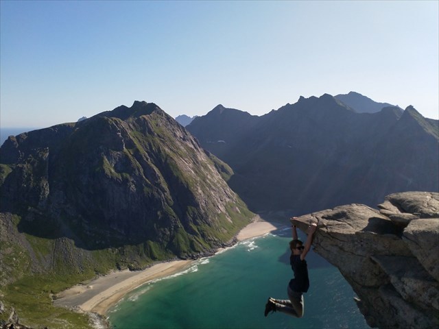
Rytentunga (Lofoten)
Hike to a famous photospot at Ryten mountain
par broiler
 Norvège > Nord-Norge > Nordland
|
|
||||
|
|||||
| Dangers |

|
| Infrastructure |

|
| Itinéraire |


|
| Waypoints |

|
| Temps |

|
| Inscription |

|
![]() Description
Deutsch
· English
(Anglais)
Description
Deutsch
· English
(Anglais)

Parking:
Here: N 68 05.436 E 013 09.397 (100 NOK, 100 SEK or 10€ accepted (info summer 2019)) or at the museum N 68 05.318 E 013 08.348 (50 NOK).
Start: N 68° 05.453 E 013° 08.866
The trail:
oneway about 4km, 540 altitude, to the photo point about 480m altitude
Your task:
Take a nice picture of you at Rytentunga. You will see: shooting the listing photo is not dangerous (even if it looks like that). Pay attention to your safety anyway. Attache your picture to your log!
Enjoy!
![]() Utilités
Utilités
 Chercher des géocaches prés:
tous -
trouvable -
même type

 Télécharger en fichier :
GPX -
LOC -
KML -
OV2 -
OVL -
TXT -
QR-Code
 Lors du téléchargement de ce fichier, vous acceptez nos conditions d'utilisation et la licence de données.
![]() Logs pour Rytentunga (Lofoten)
Logs pour Rytentunga (Lofoten)
![]() 0x
0x
![]() 0x
0x
![]() 0x
0x


 Taille : aucune boîte
 Statut : disponible
 Temps nécessaire : 5:00 h
 Distance : 8 km
 Caché en : 12. août 2019
 Inscription : https://opencaching.de/OC15A0B
 0 trouvé
 0 pas trouvé
 0 Remarques
 0 Observateurs
 0 Ignoré
 27 Visites de la page
 0 Images de log
