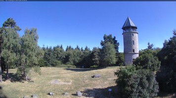
WebCam - Voilay / Tour de Matagrin
【ツ】 Put Your Hands Up in the Air...
di TofLaBeuze
 Francia > Rhône-Alpes > Loire
|
|
||||
|
|||||
| Infrastrutture |

|
| Percorso |

|
| Waypoints |


|
| Tempo |


|
| Stagionale |


|
| Listing |

|
![]() Descrizione
Deutsch
· English
(Inglese)
Descrizione
Deutsch
· English
(Inglese)
Go to the coordinates N45° 51.055' E4° 22.839'.
You will be in front of a webcam that takes a picture every 15 minutes.

Picture: violay.fr @ trinum.com
Now you need someone to save the picture of yourself taken by the webcam or save it as a screenshot on your smartphone.
To log this cache, you have to post this picture.
The picture should allow to identify you as a gecacher.
How you do that is up to you:
holding up an umbrella, banners, warning vests, balloons, headlights, or cheering into the camera... all the purpose is welcome!
![]() Suggerimenti addizionali
Suggerimenti addizionali
![]() Decripta
Decripta
Vs gur jropnz vf bssyvar, cyrnfr gnxr n cubgb bs lbhefrys be lbhe TCF/fznegcubar, fubjvat gur jropnz va gur onpxtebhaq.
A|B|C|D|E|F|G|H|I|J|K|L|M
N|O|P|Q|R|S|T|U|V|W|X|Y|Z
![]() Immagini
Immagini
![]() Utilità
Utilità
 Cerca geocache vicine:
tutte -
ricercabile -
stesso tipo

 Scarica come file:
GPX -
LOC -
KML -
OV2 -
OVL -
TXT -
QR-Code
 Scaricando questo file accetti i nostri termini di utilizzo e la Licenza dati.
![]() Log per WebCam - Voilay / Tour de Matagrin
Log per WebCam - Voilay / Tour de Matagrin
![]() 0x
0x
![]() 0x
0x
![]() 0x
0x


 Dimensioni: nessun contenitore
 Stato: disponibile
 Nascosta il: 05. settembre 2017
 Listing: https://opencaching.de/OC13EA5
 0 trovata
 0 non trovata
 0 Note
 1 Osservatore
 0 Ignorata
 79 Pagina visite
 0 Log immagini

