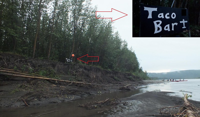
Taco Bar
A remote virtual cache located in the wilderness, accessible by a canoe, a floatplane or a dog sled in the winter.
von nh82
 Kanada
|
|
||||
|
|||||
| Gefahren |

|
| Infrastruktur |

|
| Der Weg |

|
| Wegpunkte |

|
| Zeitlich |

|
| Listing |

|
| Benötigt Werkzeug |

|
![]() Beschreibung
English
Beschreibung
English
This location should be familiar enough for anyone who has paddled down the Wind River, the Bonnet Plume River or the Snake River. I did the Snake River trip in a group of ten paddlers: we started by flying from Mayo to Duo Lakes, reached Taco Bar after two weeks and some 300 km of paddling and then continued further 220 km down the Peel River all the way to Fort McPherson, where we were picked up after four more days and then drove back to Whitehorse on the Dempster Highway.
Taco Bar is a float plane landing site on the Peel River, located at the confluence of the Snake and the Peel Rivers. There is a protected eddy channel wide enough for a plane to land and taxi on, and there is a good camping site on the southwest river bank. The site is also marked with a float plane sign, but it is hard to miss anyway because of the river junction just some 2 km upstream and the huge cutbank on the right side of the river (facing downstream) with white volcano ash stripes.
There used to be a physical geocaching.com cache GC4FXAF "Taco Bar" here; it was found only thrice and went missing after the first winter. In any case, Taco Bar is the best location for any kind of cache here, as this is the location anyone travelling down any of those three rivers would pass even in the case they opt not to continue down the Peel River all the way to Fort McPherson. Because of the restrictions on cache types at geocaching.com, I am publishing this virtual cache here.
Your task: get to this location by your preferred means (I would recommend paddling down one of the three rivers mentioned above and continuing downstream to Fort McPherson if possible, but you can also book a return trip on a floatplane or use a dog sled in the winter if you prefer), find this sign

and take a photo of yourself or your GPSr or some other personal item with the sign. Please crop or edit your photo so that the answer to the logging question is not visible. An example photo of me at the site:

Photos taken before the publication of this listing are accepted, provided that you are or your personal item is included in the photo (non-unique photos of just the sign are not accepted!). Please tell in your log how did you get there and how was your trip.
I have listed this virtual cache as D1/T5, as the location of the sign is obvious as long as you get to the GZ somehow, but getting to the GZ requires either a floatplane, a canoe or a dog sled in the winter.
There is a dry toilet in the forest very near the sign, but I doubt anyone would like to use it anyway. Some climbing is needed if you want to reach the sign from the river bank. If you choose to approach through the woods from the gravel bank, then no climbing is needed. Happy hunting!
Password to log: what (rather unexpected, given the location) amenity is free here, according to the sign? Use small letters only.
![]() Verschlüsselter Hinweis
Verschlüsselter Hinweis
![]() Entschlüsseln
Entschlüsseln
Znxr fher lbh unir rabhtu fcner onggrevrf (naq/be n fbyne cnary punetre) jvgu lbh! Vs lbh unir gnxra ybgf bs cubgbf qhevat lbhe qrfprag sebz gur Qhb Ynxrf, gur Obaarg Cyhzr Ynxr be gur ZpPyhfxl Ynxr naq unir abg cnpxrq rabhtu fcnerf, punaprf ner gung lbhe onggrevrf ner ehaavat bhg ol gur gvzr lbh trg urer. Or njner gung gurer vf ab pryy cubar erprcgvba va guvf nern (be naljurer ryfr nsgre yrnivat Znlb), fb gur bayl jnl gb pbagnpg nalbar va gur bhgfvqr jbeyq vf ol n fngryyvgr cubar!
A|B|C|D|E|F|G|H|I|J|K|L|M
N|O|P|Q|R|S|T|U|V|W|X|Y|Z
![]() Hilfreiches
Hilfreiches
 Suche Caches im Umkreis:
alle -
suchbare -
gleiche Cacheart

 Download als Datei:
GPX -
LOC -
KML -
OV2 -
OVL -
TXT -
QR-Code
 Mit dem Herunterladen dieser Datei akzeptierst du unsere Nutzungsbedingungen und Datenlizenz.
![]() Logeinträge für Taco Bar
Logeinträge für Taco Bar
![]() 0x
0x
![]() 0x
0x
![]() 0x
0x


 Größe: kein Behälter
 Status: kann gesucht werden
 Versteckt am: 07. August 2019
 Listing: https://opencaching.de/OC159F0
 0 gefunden
 0 nicht gefunden
 0 Bemerkungen
 0 Beobachter
 0 Ignorierer
 18 Aufrufe
 0 Logbilder
