| Langue : |


|
Pays : |


| Suivez-nous : | |||
| Contact us: | |
| Rejoignez les discussions : | ||||
|
|
Forum d'Opencaching | |||

|
Groupe Facebook | |||

|
GitHub | |||

|
Slack | |||

 Autriche > Steiermark > Graz
|
|
||||
|
|||||

 Taille : petit
 Statut : disponible
 Temps nécessaire : 2:30 h
 Caché en : 05. mars 2023
 Aussi listé au :
  1 trouvé
 0 pas trouvé
 1 Note
 1 Log maintenance
 1 Observateur
 0 Ignoré
 99 Visites de la page
 0 Images de log

 Listes de cache
| Dangers |


|
| Infrastructure |


|
| Itinéraire |

|
| Waypoints |

|
| Temps |

|
![]() Description
Deutsch
· English
(Anglais)
Description
Deutsch
· English
(Anglais)
At your own risk you can jump directly to Part 2 (Orienteering Fieldwork). There all what is needed for puritans is provided.
Part 1: General information
Target audience/What to expect: This cache is targeted towards people who enjoy orienteering tasks and walking or running off-trail. Those who prefer relaxing walks along trails with a clear target location should give it a second thought whether they want to go for this cache. Those with no experience with orienteering maps are recommended to first visit an orienteering cache based on an easier orienteering course in easier terrain, such as the the one in the Hilmteich area. (Note added: That cache got archived in December 2023, but a successor on a to some extent terrainwise more challenging course got hidden). Being able to interpret the brown contour lines is quite important for this cache if you do not want to end up erring around.
What not to expect: This cache is set-up as letterbox hybrid for a number of reasons. To avoid disappointments think of the cache as a multi cache with intermediary stages which can be visited in any order and for which no coordinates are provided. As required for letterbox hybrids the relatively small container contains a stamp (actually even two, both self-carved and nothing fancy) but intentionally no ink pad. Neither expect a letterbox clues based way to the final nor postcards inside the container. Moreover, also do not expect being provided with any sort of banner - this cache is about the outdoor experience.
Mandatory preparation (Map needed!): This cache requires some planning ahead as the following orienteering map (attention: link starts external download link of the map in pdf format) is essential for this cache. I strongly recommend to bring along a printed version of the map (in at least A4 format and of course in color) even to those who normally cache in a paper-less manner.
If you have little to no experience with orienteering maps and still decide to go for this cache, you might want to familiarize yourself with the specifics of orienteering maps in advance. If you can read German the legend of the map will help you. Otherwise, you might want to consult an introductory source like this one or take along this sheet. The information about the post locations (control descriptions) is provided in text form only on the map and are written in German but is not needed to locate the posts. Upon request I can provide a non verbal version of the control descriptions based on the IOF symbols.
Spirit of the cache: This cache is all about the experience of orienteering and hence no coordinates are provided for the posts (the intermediary 12 cache stages). Your task is to locate them based on the orienteering map. Creating digitized maps and trying to obtain approximate coordinates for the posts is against the spirit of the cache. The cache is not intended as a team cache meaning that each visitor is expected to visit all posts.
Needed equipment: Apart from the map mentioned above and a writing utensil not much is needed. I recommend to wear good shoes and clothes than can get dirty (I would not recommend shorts). It is up to you whether you want to bring along a compass: the area provides many catch features and hence one cannot get lost anyway. If you wish to use the stamp(s), you need to bring along your own ink pad or a highlighter pen and something to wipe off excess colour after usage of the stamp(s).
Terrain: Note that some of the posts are in terrain which can be challenging in particular when the ground is slippery. The T rating has been chosen on the basis of the most difficult sections which are short - most parts are easier. I recommend to choose your route wisely and to not come after heavy rain fall or when the ground is icy except when you are very experienced in off-trail terrain.
Route length and time requirements: As the posts can be visited in any order and as the total distance depends heavily on the chosen route (more comfortable but longer vs. very direct and challenging) the resulting mileage might vary considerably. Expect something between 4-6 km and some up and downs due to the hilly character of the area. Plan for at least 2 hours when doing the cache in walking mode and for 3 hours if you are not experienced in orienteering and/or decide for longer but more comfortable routes or decide to take breaks along the way.
Public transportation: The start can be conveniently reached by public transportation as the terminus of tram line 1 and bus stops are nearby.
Parking: While I recommend to come by bicycle (convenient bicycle racks are available at the tram terminus) or public transportation, parking is available for those who come by car at the park and ride parking lot next to the tram terminus (green zone, parking fee Mo-Fr 9-20) or up at the church (smaller, free of charge).
Part 2: Orienteering Fieldwork
Your Task:
-
Visit all 12 posts of the red course (external download link for map in pdf format) of the orienteering park Mariatrost where in 2020 two permanent orienteering courses got established (a further one is in the planning stage).
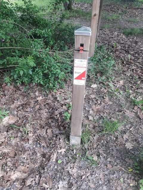
In principle you can visit the stages in any order and decide whether to start at Start 1 or Start 2 (see trailheads). Sticking to the chronological order is a proper choice in any case. - The posts are made of wood and have plates with the red-white orienteering logo attached to them (for an example see this photo). At each of the posts you will find a two letter code. Note down the letter codes. They are needed to obtain the coordinates of the final.
If you are unsure whether you found the right post, check whether the number code on the post matches with the number provided on the map for your target post (e.g. 32 for post 10).
Part 3: Final
Before providing the details for the final step I would like to ask you to take the following two requests into account:
- Please avoid spoilers which give away information about the stages or the location of the final
(e.g. do not describe your way to the final in your log) and do not share the final coordinates. I invested quite some effort and time into this cache and I do not want to get it ruined by thoughtless logs/actions in a few seconds.
- The container contains two self-carved stamps (a smaller and a larger one) but no ink pad. The smaller one is easier to use without having a firm underground. Please treat the stamps with care, do not take them along and wipe off excess colour from the stamps after stamping with your own ink pad or highlighter pen.
Please also treat the container and its contents with care. I have visited the container 3 times since I have hidden it and it was always in perfect condition while I notice that often caches quickly deteriorate once they have been published (e.g. zip lock bags get quickly ruined).
Having visited all 12 stages you are now ready to obtain the coordinates of the final. You can choose which of the two provided methods you prefer to reach your goal.
Method 1: Online Tool (requires internet access, but no calculations)
- Enter the 12 letter codes obtained at the 12 posts into the Multi-Checker tool.
- If all codes are correct, you will be provided with the final coordinates.
Method 2: (Manual) Calculation
Upon request I can offer a calculation sheet (xlsx) that performs the calculations outlined below upon entering the 12 codes. If someone is willing to host the file, it can be made available to the public. My guess is however that most cachers who possibly would use the calculation sheet, will rather use the multichecker anyway.
The minority who is going for the manual calculation path will certainly be able to find a bench at a convenient location for sitting down and doing the work.
Perform the following steps for all posts i from 1 up to 12.
- Let Xi be the positional number of the first letter of the two-letter code obtained at post i in the Latin alphabet (A=1, B=2, etc). (For example, if the code for post 1 were AY, then X1=1.)
- Let Yi be the positional number of the second letter of the two-letter code obtained at post i in the Latin alphabet (A=1, B=2, etc). (For example, if the code for post 1 were AY, then Y1=25.)
- Calculate Zi = 2*Xi + Yi.
Now only the following calculations remain to be done.
- A = 10 * (Z3 + Z4 + Z5 + Z8) - 4 * (Z1 + Z9) + 7
- B = 7 * (Z2 + Z6 + Z7 + Z12) - 2 * (Z10 + Z11) + Z5 + 3
- C = 5.500 + A / 1000
- D = 29.300 + B / 1000
The final is located at N 47° C' E 15° D'
Change log:
June 4, 2023: Added link to German description.
June 4, 2023: Fixed a minor mistake (pdf instead of jpg).
January 22, 2024: Map link updated.
 Des waypoints supplémentaires
  Autres systèmes de coordonnées
|
N 47° 06.230' E 015° 29.390' |
P+R Mariatrost (Green zone, parking fee Mo-Fr 9-20, weekend free of charge) P+R Mariatrost (Grüne Zone, gebührenpflichtig Mo-Fr 9-20, gratis am Wochenende) |
||
|
N 47° 06.400' E 015° 29.570' |
Parking Church Mariatrost (free of charge) Parkplatz Kirche Mariatrost (gratis) |
||
|
N 47° 06.294' E 015° 29.404' |
Start 1 | ||
|
N 47° 06.246' E 015° 29.746' |
Start 2 |


 Les autres points de passage sont affichés sur la carte lorsque le cache est sélectionné, sont inclus dans le téléchargement de fichiers GPX et seront envoyés à l'appareil GPS.
![]() Images
Images
![]() Utilités
Utilités
 Chercher des géocaches prés:
tous -
trouvable -
même type
Chercher des géocaches prés:
tous -
trouvable -
même type
 Télécharger en fichier :
GPX -
LOC -
KML -
OV2 -
OVL -
TXT -
QR-Code
Lors du téléchargement de ce fichier, vous acceptez nos conditions d'utilisation et la licence de données.
Télécharger en fichier :
GPX -
LOC -
KML -
OV2 -
OVL -
TXT -
QR-Code
Lors du téléchargement de ce fichier, vous acceptez nos conditions d'utilisation et la licence de données.
![]() Logs pour Orienteering with Mary: Challenging or comforting?
Logs pour Orienteering with Mary: Challenging or comforting?
![]() 1x
1x
![]() 0x
0x
![]() 1x
1x
![]() 1x
1x
 22. janvier 2024
cezanne
a maintenu la géocache
22. janvier 2024
cezanne
a maintenu la géocache
[EN:] The map link got updated. That change has happened very recently and not even the web page of the SUSO orienteering club has already been updated. Thanks for the heads-up.
[DE:] Der Kartenlink wurde aktualisiert. Diese Änderung erfolgte sehr kürzlich und nicht einmal die Webseite des OL Vereins SUSO hat dem schon Rechnung getragen. Danke für das Aufmerksammachen.

 26. novembre 2023
josopun
trouvé la géocache
26. novembre 2023
josopun
trouvé la géocache
Am 19.11.2023 die Kontrollpunkte gesucht und gefunden.
Achtung Nummer 8 wurde ausgerissen und abseits abgelegt.
Am 26. November 2023 Final besucht.
 04. juin 2023, 10:16
Eagle_
a écrit une note
04. juin 2023, 10:16
Eagle_
a écrit une note
Super, ein neuer Cache von der Meisterin, und dann auch gleich ein OL Postennetz. Was kann es besseres geben..
Mal sehen wann ich es nach Maria Trost schaffe